Southwest Sierra #65 — History That Shaped Our Landscape
July 5, 2024

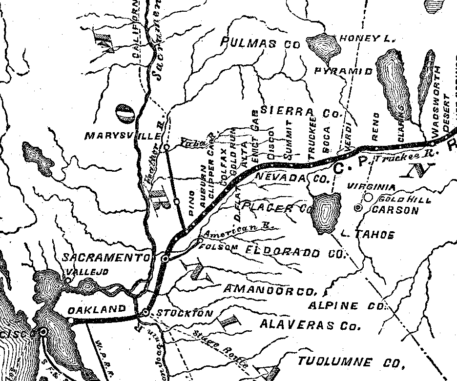
Dark line with white dots is the path of the first transcontinental railroad through Northern California. The original starting point was in Sacramento, with other railroad lines added later. Map courtesy of the Central Pacific Railroad Photographic History Museum CPRR.org.
(continued from last week) As promised, this week’s article will explore the origins of the checkerboard of private and public land across the west and specifically in our area of the Tahoe National Forest.
It all starts with surveys. Thomas Jefferson was an early proponent of the Public Land Survey System (PLSS) that is still used today. The necessity for such a system arose out of the need to survey the land deeded to the U.S. by the original 13 colonies after the Revolutionary War ended, and for land deeded in the 1783 treaty of Paris. The system was made official by the passage of the Land Ordinance of 1785 which was further refined by the Northwest Ordinance passed two years later. “Under Congressional mandate, cadastral surveys (surveys of the boundaries of land parcels) were undertaken.” The PLSS provided a means for the U.S. Government to “dispose of” [sell or otherwise transfer] lands in the public domain.
The PLSS is managed and regulated by the U.S. Bureau of Land Management (BLM). BLM is the record keeper of over 200 years’ worth of cadastral survey records and plats. This is not a static collection; it is still growing. Most new surveys are being done in Alaska. Without going into the details of the system, its basic organization is a series of 6 mile square townships, that are further divided into thirty-six 1-mile square sections. [most information above from nationalatlas.gov]
Those 1-mile square sections are the squares of our “checkerboard”. In theory a 1-mile square should cover an area of 640 acres and this is true if the land is flat. The squares are drawn as if from the air, to keep their symmetry. As such, they don’t take into consideration the slope of the land. The steeper the terrain, the greater the area within each square.
Now, back to our railroad history from the book Land In California by W.W. Robinson. The Pacific Railroad Bill’s purpose was “to aid in the construction of a railroad and telegraph line from the Missouri River to the Pacific Ocean, and to secure to the Government the use of the same for postal, military and other purposes.” Previously, states had acted as trustees and agents for selling off public lands to fund roads, canals and railroads, but this new bill empowered the Union Pacific Railroad Company and the Central Pacific Railroad Company of California to be the direct recipients of the land grants, and to handle all aspects of laying out, building, and maintaining the railroad and telegraph lines.
A right-of-way or easement 400 feet wide (approximately 200 feet on each side of the track) was granted along with ground for stations, buildings, shops, depots, switches, sidetracks and turntables. [Note: this was not an outright land grant, as the easements had many strings attached]. The railroad companies were also given the right to use natural resources including earth, stone and timber from public lands adjacent to the tracks for constructing the railroad. Additionally, each company was granted every alternate section of public land designated by odd numbers, to the amount of ten alternate sections per mile on each side of the railroad within 20 air miles of each side of the track. [The origin of our checkerboard!] There were exceptions for land previously deeded to homesteaders and other preemptive rights. There was an exception for “all mineral lands” and some other conditions which I won’t detail.
The Central Pacific, laying rail east from Sacramento was soon in mountainous terrain. What I gathered from W.W. Robinson is that the 1864 amendment to the Railroad Bill doubled the amount of land granted to the Central Pacific. The justification for this was that the land in the Sierras was not “arable” and was considered “worthless”. [end W.W. Robinson info.] Robinson doesn’t mention it, but in addition to the lack of arable land, the Central Pacific must have argued that getting through the Sierra Nevada Mountains was going to cost much more than anticipated.
By 1870 both The Central Pacific Railroad Company and the Southern Pacific Railroad Company had the same directors and management, essentially combining the two companies. Eventually the Central Pacific Railroad Company was merged with The Southern Pacific Railroad Company (per CPRR.org).
Currently, the owner of the majority of the “white” or private sections of property in our area is Southern Pacific Industries (SPI). I was unable to find information on SPI’s exact relationship to the Southern Pacific Railroad Company in time for this week’s deadline. I sent an inquiry to SPI’s public relations department and will continue my search. Meanwhile, wishing everyone a safe and fun Fourth of July Holiday!
Featured Articles

Storms Bring Heavy Rainfall and Local Disruptions →
December 22, 2025
Sierra County faces power outages and water issues amid heavy rainfall and storm warnings.
215 Animals Seized for Cruelty from Grass Valley Property →
December 22, 2025
Human Remains Found Near South Yuba Bridge in March Identified →
December 17, 2025
Transfer Station Burn Suspended After Community Concerns →
December 16, 2025
Sierra Hardware Plans Extensive Repairs After Flood Damage →
December 8, 2025