Cal Fire Maps Bring State Rules to Local Doorsteps
Governor Newsom’s order prompts CAL FIRE to reclassify 1.4 million acres as high-risk, enforcing state fire mitigation rules locally.
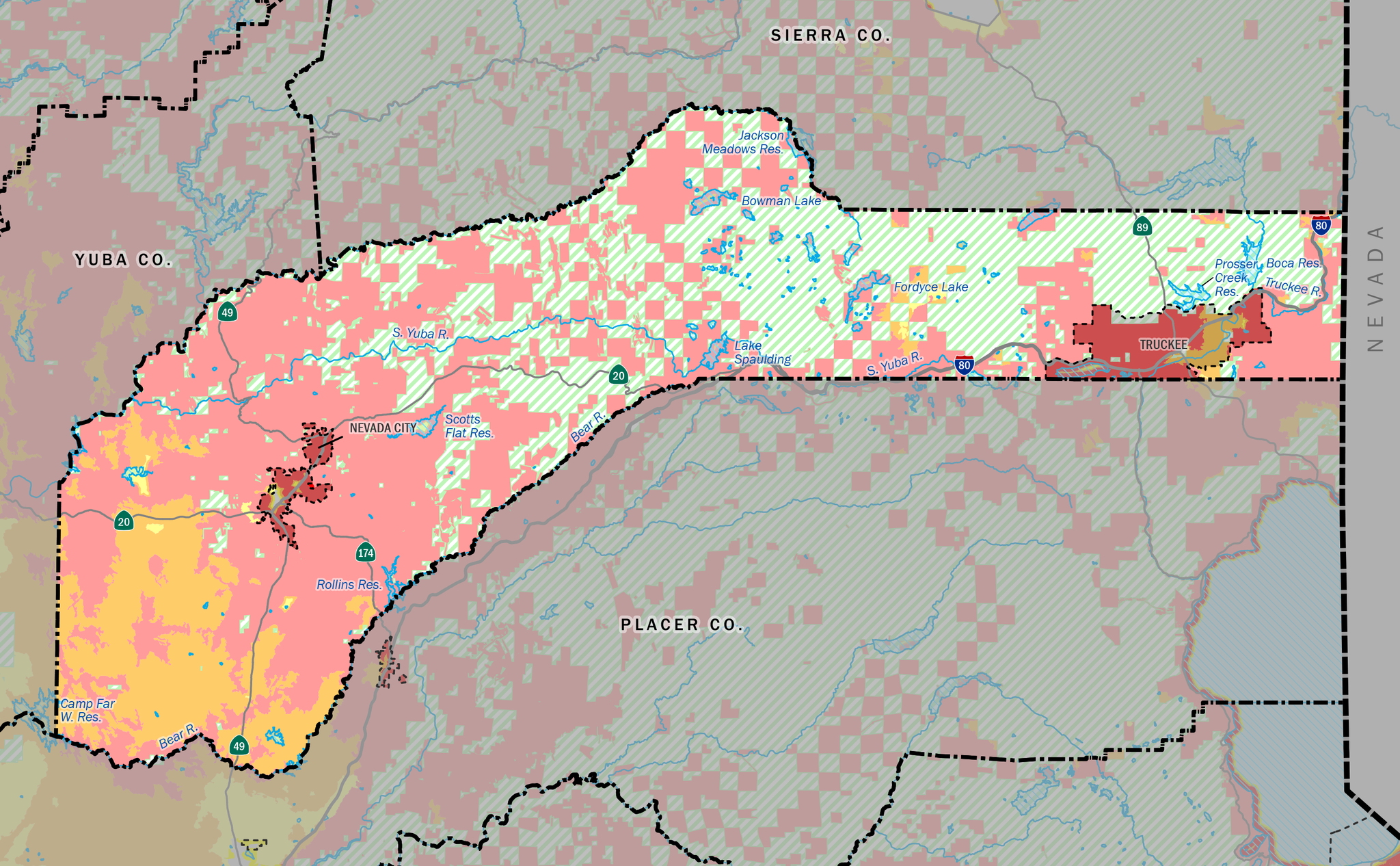
Cal Fire classifies the majority of Nevada County as “high” (orange) or “very high” (red) fire risk. Darker areas mark changes in Local Responsibility Areas. Image taken from Cal Fire’s official Fire Hazard Severity Zone map.
SACRAMENTO — On February 6, 2025, Governor Newsom’s executive order spurred Cal Fire to release updated maps, reclassifying 1.4 million acres as “high” or “very high” risk zones. In practice, the new maps will require local jurisdictions in high-fire-risk zones to comply with state fire mitigation rules. Newsom’s order instructs that the codes now include an ember-resistant zone within 5 feet of structures, called “Zone 0,” alongside 100-foot defensible space rules.
Zone 0 requires that no combustible material be placed within 5 feet of a structure. Mulch walkways and wooden fences must be removed or replaced with fire-resistant material. Only sparse, well-irrigated plants such as succulents are allowed; nothing should overhang or touch the building. Additionally, loose debris like pine needles must be continuously cleared from the zone to maintain its integrity. Locally, the zone will be applied nearly universally, potentially at a substantial cost to property owners who must comply in the coming years.
In Sierra County, Zone 0 rules will apply to most structures outside of Loyalton, which will also be affected in small pockets. High fire-risk towns like Downieville and Sierra City already fall into State Responsibility Areas and are used to complying with California’s fire codes, but Zone 0 is a new regulation. In the neighboring counties of Plumas and Nevada, Truckee, Nevada City, Grass Valley, and Portola must all realign fire codes to State standards.
Nevada County will experience particularly sweeping changes, starting with the Town of Truckee, which is now almost entirely classified as a “High” or “Very High” Fire Hazard Severity Zone. Despite the reclassification, Truckee Fire Protection District Chief Kevin McKechnie says little will change for existing property owners. “At Truckee Fire, we’ve been trying to implement Zone 0 for new construction for a while now. Our recommendation is to maintain that Zone 0 up to 5 feet; it may not be a point of enforcement, but it’s definitely a recommendation,” explains McKechnie.
Beyond Zone 0, McKechnie emphasized that new construction must comply with more stringent fire-hardening practices, including potentially increased setback distances. Where Truckee homes can be spaced as close as 20 feet from each other in a typical subdivision, that distance may be increased to as much as 40 feet or even 60 feet for larger lots, as outlined in the proposed Truckee Housing Element. Such regulation is not a result of the Cal Fire maps directly but would be implemented in the Truckee General Plan to be adopted later this year.
According to McKechnie, further fire-prevention measures are in the works, such as limiting development along dead-end roads. He says that improving the ability to evacuate an area and facilitating better access for firefighters are keys to keeping people safe. Dead-end roads can be a fatal restriction, as demonstrated by recent fires in southern California and more local examples such as the 2018 Camp Fire in Paradise.
While Truckee property owners may be able to adapt swiftly, Grass Valley and Nevada City, which have different fire hardening codes and less enforcement capacity, could face bigger hurdles. Still, the cities have already adopted 100-foot defensible space zones mirroring state code, and local ordinances require further clearing of flammable vegetation, so impacts may be limited.
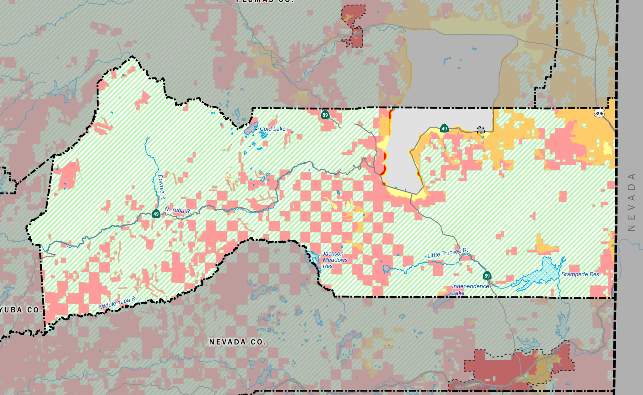
Sierra County has few LRAs, but much of its habited area is designated “very high” fire risk.
Cal Fire maps can inform insurers, potentially leading to higher premiums in zones now classified as high fire risk, but increased home hardening and risk reduction in those communities could ideally lead to rate reductions in the long term. However, increasing reliance on the California FAIR Plan and larger insurance companies choosing to pull out of California due to state policy decisions are issues overshadowing any potential rate reduction. The problem is only expected to be exacerbated after the California Insurance Commissioner denied a request last week by the State’s largest insurer, State Farm, for an “emergency” rate increase in the wake of the southern California fires.
Local governments have 120 days to adopt the new Cal Fire maps, after which new restrictions will go into effect immediately. The level of enforcement for the regulations is likely to vary, but Chief McKechie says the Truckee Fire Protection District tends to focus on information and education over handing out fines. The District already tries to facilitate compliance by offering programs such as roadside pickup for combustible material and keeping a list of contractors that can help with home hardening. Once fully adopted, the new Zone 0 rules will apply to most inhabited areas of Sierra, Plumas, and Nevada Counties.